


Courboyer 12

togolo28
User
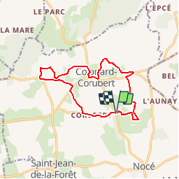

Length
12.5 km

Max alt
253 m

Uphill gradient
258 m
Km-Effort
16 km

Min alt
164 m

Downhill gradient
260 m
Boucle
Yes
Creation date :
2018-02-22 00:00:00.0
Updated on :
2018-02-22 00:00:00.0
3h24
Difficulty : Easy

FREE GPS app for hiking
 SityTrail
IGN / Geographical institutes
SityTrail Plus
The world is yours!
About
Trail Walking of 12.5 km to be discovered at Normandy, Orne, Perche en Nocé. This trail is proposed by togolo28.
Positioning
Country:
France
Region :
Normandy
Department/Province :
Orne
Municipality :
Perche en Nocé
Location:
Nocé
Start:(Dec)
Start:(UTM)
327351 ; 5363074 (31U) N.
Comments